An 1864 flood on the Cache la Poudre River is the reason the city carries the name Fort Collins: the flood destroyed Camp Collins at La Porte, and the military relocated the camp and renamed it. The river still produces periodic flooding, and anyone building an industrial site in the valley inherits that history in the form of drainage criteria, floodplain mapping and detention requirements.
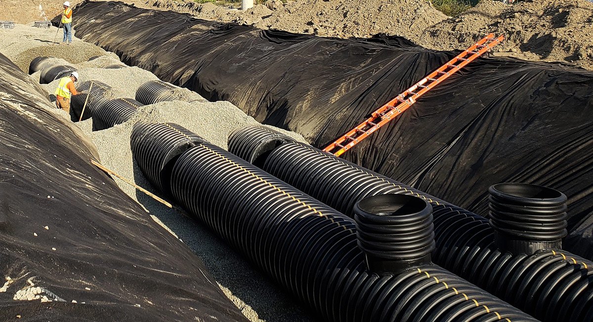
Large industrial sites shed a great deal of water. A roof of several hundred thousand square feet and a paved truck court turn a storm into a short, concentrated flow, and the jurisdiction expects the site to hold and release it at a controlled rate. We design, build and coordinate the storm system as a working part of the plant, including the details that are easy to overlook, such as inlet protection, trench drains at dock doors and cleanouts in pavement: collection from roofs and yards, conveyance by pipe and swale, detention in a pond or underground vault, and an outfall that the downstream owner will accept.
The work spans grading, utilities and paving, so it has to be sequenced with all three. We treat drainage as an element of the site plan that the plant relies on every day, not as a permit condition to satisfy once.
A river valley that floods
The record is specific. A late July 1997 flash flood in Fort Collins followed 10 to 14 inches of rain over 31 hours, killed five people, caused about $5 million in city damage and about $140 million in damage to Colorado State University. In September 2013, four days of heavy rain flooded Loveland along the Big Thompson River and closed roads. These events shape local expectations about how much water a site should hold and where it should go.
Those expectations reach industrial parcels near Laporte and along the Poudre, and parcels near the Big Thompson in Loveland. After the 2013 flood, Estes Park adopted a one foot freeboard standard, and a post-flood report noted that every structurally damaged building there was outside the mapped floodplain. The lesson for a plant owner is that a mapped boundary is a minimum, and finished floor elevations deserve a margin.
Criteria, review and approvals
Drainage review sits alongside the building permit and often runs on its own track. The jurisdiction expects a drainage report that sets out existing and proposed flows, the detention volume, the release rate and the water quality treatment. Colorado also asks jurisdictions that update their building codes to adopt energy standards under HB22-1362, but stormwater criteria are a local matter, so we confirm the standards for each parcel before design starts.
Floodplain permits add time where a parcel touches a mapped flood hazard area. We identify those parcels during permitting and entitlements coordination and plan the survey, the engineering and the review into the schedule. Downstream easements, outfall agreements and ditch company consent may also be needed, and they take longer than most owners expect.
Building the system in the right order
We schedule and supervise the earthwork, storm pipe, structures and pond construction so that one project team carries the drainage from rough grade to final stabilization. The sequence matters: the detention pond often doubles as a temporary sediment basin during construction, so it is built first, lined or protected, and converted to its permanent configuration at the end. Skipping that step means paying twice to fix a basin full of silt.
Pipe and inlet installation follows the grading plan closely. We set invert elevations by survey, bed and backfill to specification, test where required and photograph critical connections before they are covered. Outlet structures, orifice plates and emergency spillways are built to the engineer's drawings and verified against the as-built survey. This work connects with site clearing and mass grading on one side and the paving on the other.
Making drainage serve operations
A drainage plan should be judged by how the plant operates in a storm. Trucks need to enter and leave when it rains, forklifts need dry aprons, and dock doors need grades that keep water out of the building. We check the design against those operating conditions and propose changes where an inlet sits in a wheel path or where a swale crosses a truck route.
Maintenance is part of the design as well. Detention ponds and water quality features need access for equipment, a stable outlet and a plan for sediment removal. We build with maintenance in mind and give the owner a short inspection guide with the as-built records. Where a pond sits near the truck court and trailer yard, we set the grading so that fueling or spill events can be contained.
Where drainage drives the layout
Large roofs and paved yards make warehouses and distribution buildings the most drainage-intensive product here. The building footprint, the number of dock doors and the trailer parking determine impervious area, and impervious area determines detention volume. A plant owner who understands that link can sometimes reduce cost by adjusting the layout before the site plan is submitted.
Food and beverage plants add washdown and process water, which must be kept separate from stormwater. Manufacturing sites with outdoor storage need controls on runoff quality. We coordinate those requirements with the process team so that the storm system and the process drains do not conflict.
Show us the parcel and the river or ditch beside it
Send the survey and the proposed building. We will outline the drainage criteria, the likely pond size and the schedule for approvals.
Common Questions
How large a detention pond will my plant need?
The size depends on the impervious area, the jurisdiction's release rate and the soils. A large building with a big truck court needs a bigger pond than a small building on the same lot. We calculate the volume early so the pond appears on the site plan before the building footprint is fixed.
Can detention be placed underground to save land?
Yes. Underground vaults and chambers can free surface area for trucks and expansion, but they cost more and require inspection and maintenance access. We compare the options on cost, land value and maintenance.
What if my parcel is near a mapped floodplain?
The floodplain adds survey, engineering and review time, and it may set a minimum finished floor elevation. Because mapped boundaries are minimums, we usually recommend extra freeboard. We identify the issue during site selection, so it shapes the price you pay for the land.
How do you keep the pond from filling with silt during construction?
We build the pond first and use it as the sediment basin, with outlet protection and perimeter controls feeding it. Before final stabilization, we clean it out, shape it to the permanent grades and install the final outlet. This avoids buying the pond twice and keeps downstream channels clean.
Who inspects the drainage system?
The jurisdiction inspects pipe, structures and the final pond configuration, and the engineer of record certifies the as-built conditions. We schedule inspections ahead of backfill and document each stage with photographs and survey records.
Related
Related Services
Related Building Types
Related Service Areas
Ready to talk about your project?
Request a Project ReviewOne project team for the whole sequence
Industrial Contractors of Fort Collins reviews the site, the loads, the schedule and the approvals before pricing, then schedules, coordinates and inspects the specialty trade partners from preconstruction through closeout.